Understanding how land size is measured in Nigeria is essential for anyone buying, selling, or investing in real estate. Land measurement determines the value of property, the type of development possible, and the legal documentation involved. Many buyers are confused by terms like plot, hectare, acre, and square meter, especially because measurement standards can vary depending on location and estate layout. This article explains clearly how land sizes are measured in Nigeria and how to interpret them correctly.
Why Land Measurement Matters
Land measurement is important because it defines the exact size and boundaries of a property. Without proper measurement, disputes can arise, and buyers may receive less land than they paid for.
Land measurement helps to:
-
Determine the true value of land
-
Ensure accurate property documentation
-
Prevent boundary disputes
-
Guide building and development planning
-
Ensure compliance with government regulations
Accurate measurement protects both the buyer and seller.
Standard Unit of Land Measurement in Nigeria
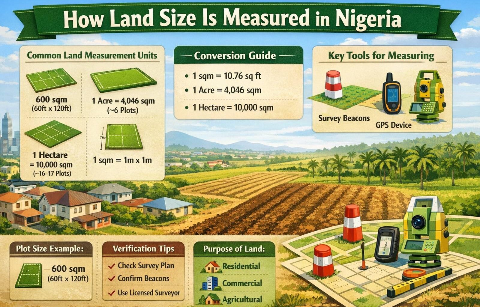
The official and standard unit of land measurement in Nigeria is the square meter (sqm). This is the unit used by surveyors, government agencies, and legal documents such as the Certificate of Occupancy (C of O).
A square meter simply means a square that measures 1 meter by 1 meter.
Other larger units are derived from square meters, including plots, acres, and hectares.
Common Land Measurement Units Used in Nigeria
Although square meters are the official standard, several other units are commonly used in Nigeria’s real estate market.
Square Meter (sqm)
Square meter is the foundation of all land measurements.
Examples include:
-
300 sqm
-
450 sqm
-
500 sqm
-
600 sqm
Most residential plots in Nigeria range between 450 sqm and 600 sqm.
Survey plans always show land size in square meters.
Plot
A plot is not an official measurement unit but a commonly used real estate term in Nigeria. Its size can vary depending on the state, developer, or estate layout.
In most parts of Nigeria:
-
Standard plot = 600 sqm
-
Some estates use 500 sqm
-
Some use 450 sqm
Always confirm the square meter size of a plot before buying, because not all plots are equal.
For example:
-
1 plot may be 600 sqm in one estate
-
1 plot may be 500 sqm in another estate
The square meter measurement is the accurate reference.
Half Plot
A half plot is simply half of a full plot.
Examples include:
-
Half plot of 600 sqm = 300 sqm
-
Half plot of 500 sqm = 250 sqm
-
Half plot of 450 sqm = 225 sqm
Half plots are often used for smaller residential buildings.
Acre
An acre is a larger land measurement unit often used for farmland, estate development, and large investments.
1 acre equals:
-
4,046 square meters
This means:
-
About 6 standard plots of 600 sqm make 1 acre
Acre is commonly used in agricultural investments such as palm oil farms and cocoa farms.
Hectare
A hectare is an even larger unit used for major estate developments, agricultural projects, and government land allocation.
1 hectare equals:
-
10,000 square meters
This means:
-
About 16 to 17 standard plots of 600 sqm make 1 hectare
Hectare is commonly used when measuring large land areas such as estates, farms, and institutional land.
Common Plot Dimensions in Nigeria
Plots are often described using length and width measurements.
A standard plot of 600 sqm typically measures:
-
60 feet by 120 feet
Converted to meters, this equals approximately:
-
18 meters by 36 meters
Other common plot dimensions include:
-
50 feet by 100 feet
-
50 feet by 120 feet
-
40 feet by 80 feet
Surveyors convert all these measurements into square meters.
Conversion Between Feet and Square Meters
Nigeria uses both feet and meters in land measurement. Survey plans usually use meters, but local descriptions often use feet.
Basic conversion facts:
-
1 meter = 3.28 feet
-
1 square meter = 10.76 square feet
-
600 sqm = 6,458 square feet
Understanding this conversion helps buyers verify land size correctly.
How Surveyors Measure Land in Nigeria
Licensed surveyors are responsible for measuring land accurately. They use professional tools and techniques to determine boundaries and size.
Surveyors use tools such as:
-
Measuring tapes
-
Total station machines
-
GPS devices
-
Survey beacons
They calculate the land area and produce an official survey plan.
A survey plan includes:
-
Land size in square meters
-
Boundary measurements
-
Beacon numbers
-
Location details
-
Surveyor registration number
This document is essential for legal ownership.
Survey Beacons and Their Importance
Survey beacons are physical markers placed on land to define its boundaries.
Beacons help to:
-
Identify the exact corners of the land
-
Prevent encroachment
-
Protect the owner’s property
-
Ensure accurate land measurement
Each beacon has a unique number recorded on the survey plan.
Never buy land without confirming the beacon locations.
Estate Plots vs Government Plots
Land measurement can vary depending on whether the land is in a private estate or government layout.
Private estate plots may be:
-
450 sqm
-
500 sqm
-
600 sqm
Government plots are usually standardized at:
-
600 sqm
However, modern estates often reduce plot size to make land more affordable.
Always confirm the exact size in square meters.
Residential vs Commercial Land Sizes
Different land sizes are suitable for different purposes.
Residential land sizes:
-
300 sqm for small houses
-
450 sqm for standard homes
-
600 sqm for duplex and larger homes
Commercial land sizes:
-
600 sqm and above
-
1 acre and above for major projects
Agricultural land sizes:
-
1 acre
-
2 acres
-
5 acres
-
1 hectare or more
Mistakes Buyers Make When Checking Land Size
Many land buyers make mistakes due to lack of understanding.
Common mistakes include:
-
Assuming all plots are 600 sqm
-
Not checking the survey plan
-
Ignoring beacon verification
-
Relying only on verbal description
-
Not using a licensed surveyor
These mistakes can lead to land loss or disputes.
How to Verify Land Size Before Buying
To avoid problems, buyers should follow proper verification steps.
Important steps include:
-
Ask for the survey plan
-
Confirm the size in square meters
-
Inspect the physical beacons
-
Use a licensed surveyor if necessary
-
Verify documents with land registry
This ensures transparency and protects your investment.
Role of Government in Land Measurement
Government agencies regulate land measurement and registration.
They ensure:
-
Accurate survey documentation
-
Proper land allocation
-
Prevention of land disputes
-
Legal recognition of ownership
Survey plans must be registered with government authorities.
Example Breakdown of Land Size
Example 1:
Land size = 600 sqm
This is equal to:
-
1 standard plot
Example 2:
Land size = 300 sqm
This is equal to:
-
Half plot
Example 3:
Land size = 10,000 sqm
This is equal to:
-
1 hectare
Example 4:
Land size = 4,046 sqm
This is equal to:
-
1 acre
Understanding these examples helps buyers interpret land measurements easily.
Conclusion
Land measurement in Nigeria is based primarily on square meters, which is the official and most accurate unit. Other common terms like plots, acres, and hectares are simply larger units derived from square meters. A standard plot is usually 600 sqm, but this can vary depending on the estate or developer.
Before buying land, always verify the size using the survey plan, confirm beacon locations, and ensure proper documentation. Understanding land measurement protects buyers from fraud, prevents disputes, and ensures they receive the exact land size they paid for.
Whether you are buying land for residential, commercial, or agricultural purposes, knowing how land size is measured gives you confidence and helps you make informed real estate decisions.